
ดร.เครือวัลย์ จันทร์แก้ว
วันที่ 26 ธันวาคม 2557 ที่จะถึงนี้ เป็นวันครบรอบ 10 ปี เหตุการณ์พิบัติภัยแผ่นดินไหวและสึนามิ ที่จัดได้ว่าเป็นพิบัติภัยธรรมชาติที่ร้ายแรงที่สุดในประวัติศาสตร์มนุษยชาติ มีจำนวนผู้เสียชีวิตกว่า 230,000 คนใน 14 ประเทศ และยังความเสียหายแก่สิ่งปลูกสร้าง ทรัพย์สิน และเศรษฐกิจในประเทศที่ได้รับผลกระทบอย่างมหาศาล
เหตุการณ์สึนามิครั้งนั้นมีผลกระทบต่อ 6 จังหวัด ชายฝั่งอันดามันของประเทศไทย โดยมีรายงานผู้เสียชีวิตกว่า 5,000 คน เหตุการณ์สึนามิครั้งนั้นถือเป็นเหตุการณ์ที่ไม่คาดคิดมาก่อนว่าจะเกิดขึ้นกับประเทศไทย ณ เวลานั้น ประเทศไทยและหลายประเทศในภูมิภาค ไม่มีศูนย์เตือนภัยสึนามิ ไม่มีกลไกและกระบวนการในการเตือนให้ประชาชนในพื้นที่เสี่ยงภัยได้ทราบถึงภัยจากคลื่นสึนามิที่เคลื่อนที่เข้ามาสู่ชายฝั่งประเทศของตน
บันทึกเหตุการณ์แผ่นดินไหว
แผ่นดินไหวในครั้งนั้นมีจุดเหนือศูนย์กลางแผ่นดินไหวอยู่นอกชายฝั่งบันดา อาเจะห์ ของเกาะสุมาตรา ประเทศอินโดนีเซีย ตรงแนวรอยมุดตัวร่องลึกซุนดา ซึ่งเป็นแนวที่แผ่นอินเดีย (Indian Plate) มุดเข้าไปใต้แผ่นยูเรซีย (Eurasian Plate) ขนาดของแผ่นดินไหว คือ Mw 9.1-9.3 (ซึ่งนักวิทยาศาสตร์ใช้เวลาเกือบ 2 ปีในการคำนวณหาขนาดที่แท้จริงของแผ่นดินไหวครั้งนี้) จัดเป็นแผ่นดินไหวที่มีขนาดใหญ่เป็นอันดับ 3 ของโลก ผลการศึกษาข้อมูลในเวลาหลายเดือนหลังเหตุการณ์ทำให้ทราบว่าการเคลื่อนผ่านกัน (rupture) ของแผ่นอินเดียลงไปใต้แผ่นยูเรเซียนั้นเกิดขึ้นจากจุดเหนือศูนย์กลางแผ่นดินไหวและไล่ขึ้นมาทางตอนเหนือมาทางหมู่เกาะอันดามัน นิโคบาร์ รวมเป็นระยะทางกว่า 1,300 กิโลเมตร และใช้เวลาทั้งหมดเกือบ 10 นาที (ซึ่งพื้นที่ที่มีการเคลื่อนผ่านกันที่มีขนาดใหญ่นี้เองเป็นสาเหตุที่ทำให้พลังงานที่ปลดปล่อยออกมา หรือ “ขนาดของแผ่นดินไหว” มีขนาดใหญ่มาก)
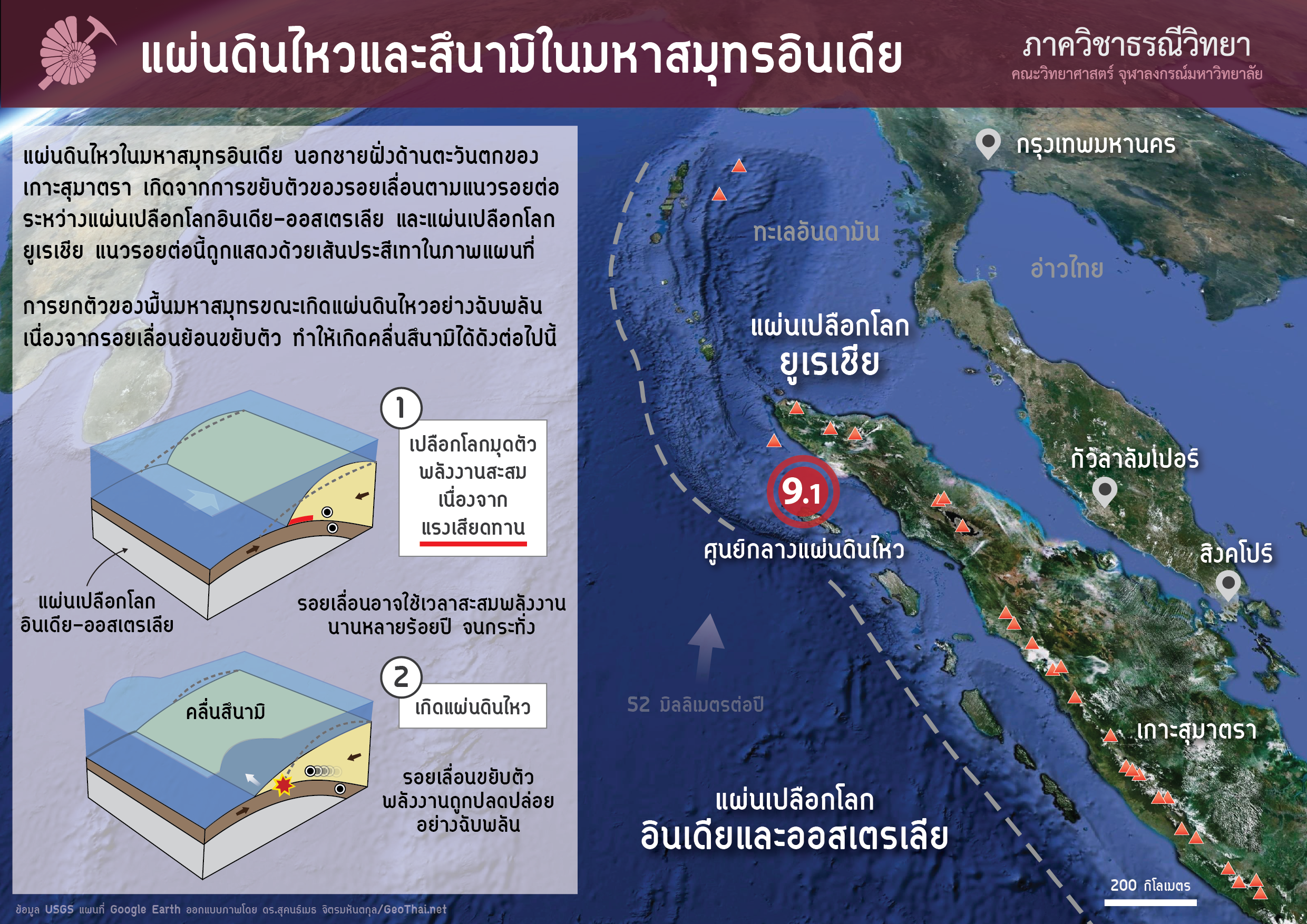
แผนที่แสดงตำแหน่งศูนย์กลางแผ่นดินไหวและกระบวนการเกิดสึนามิในมหาสมุทรอินเดีย
เหตุการณ์ที่ไม่มีใครคาดคิด
เหตุการณ์แผ่นดินไหวและสึนามิเมื่อวันที่ 26 ธันวาคม 2547 นอกจากจะเป็นเหตุการณ์ที่ไม่คาดคิดสำหรับประชาชนในภูมิภาคนี้แล้ว ในแวดวงวิทยาศาสตร์ โดยเฉพาะนักวิทยาศาสตร์ที่ศึกษาแผ่นดินไหวตามแนวการมุดตัวและสึนามิ ก็นับว่าเหนือความคาดคิด ทั้งในแง่ของตำแหน่งที่เกิดและขนาดของแผ่นดินไหว เหตุการณ์แผ่นดินไหวครั้งนี้ทำให้ทฤษฎีและความเชื่อต่างๆเกี่ยวกับแผ่นดินไหวตามแนวมุดตัวเปลือกโลกเปลี่ยนไป เช่น ขนาดและพื้นที่ที่สามารถเกิดแผ่นดินไหวขนาดใหญ่ยักษ์ (ศัพท์ทางวิชาการเรียกแผ่นดินไหวที่มีขนาด Mw > 9.0 ว่า “Giant Earthquake”) นั้นไม่จำกัดเฉพาะแต่ในเขตการมุดตัวที่มีแผ่นมีอายุน้อยๆ และมีอัตราการมุดตัว (หรืออัตราการชนกันสูง) ดังที่เคยเชื่อกันเท่านั้น นอกจากนี้ผลการศึกษาในเวลาหลายปีหลังเหตุการณ์พิบัติภัยในครั้งนี้ก่อให้เกิดทฤษฎีและความรู้ทางวิทยาศาสตร์ต่างๆตามมาอีกมากมาย
การศึกษาวิจัยและบทบาทของภาควิชาธรณีวิทยา จุฬาลงกรณ์มหาวิทยาลัย
ในประเทศไทยเอง มีผลการศึกษาจำนวนมากที่เกี่ยวกับแผ่นดินไหวและสึนามิที่เกิดขึ้น ทั้งจากทีมวิจัยต่างชาติ และทีมวิจัยไทย ในหลากหลายสาขา ภาควิชาธรณีวิทยา คณะวิทยาศาสตร์ จุฬาลงกรณ์มหาวิทยาลัย ได้เข้าไปมีส่วนร่วมในการสำรวจผลกระทบทางกายภาพของพื้นที่ 6 จังหวัด นอกจากนี้ทีมวิจัยจากภาควิชานำโดย ศ. ดร. มนตรี ชูวงษ์ ยังศึกษาตะกอนสึนามิและตีพิมพ์ผลงานทางวิชาการในวารสารวิชาการนานาชาติอีกหลายฉบับ (รวบรวมที่นี่) ซึ่งหลายงานตีพิมพ์ได้รับการยอมรับและอ้างอิงจากนักวิจัยทั่วโลกตลอดระยะเวลา 8 ปีที่ผ่านมา
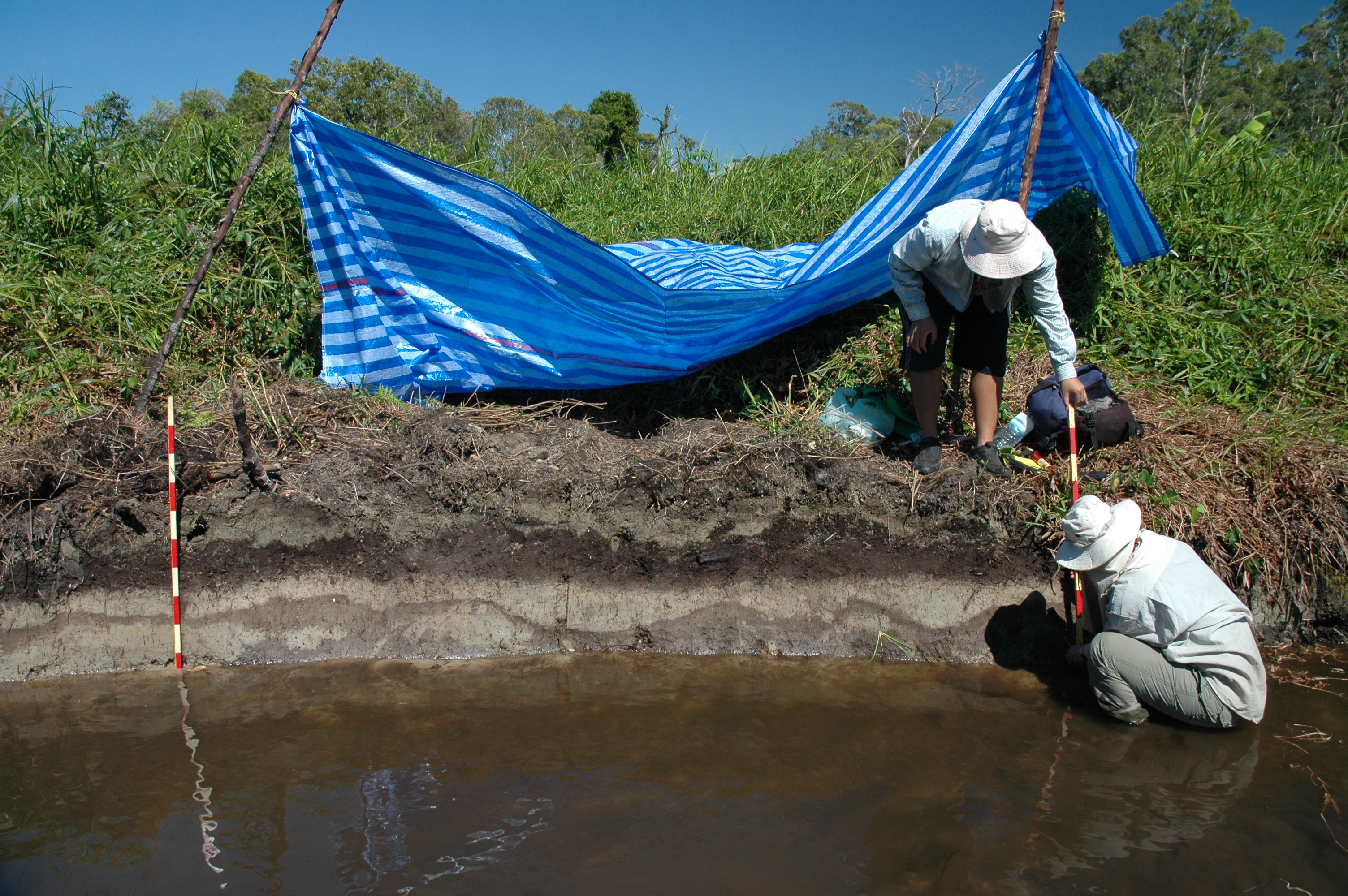
ภาพการสำรวจชั้นตะกอนที่ตกสะสมตัวเมื่อเกิดสึนามิ
สึนามิโบราณในประเทศไทย
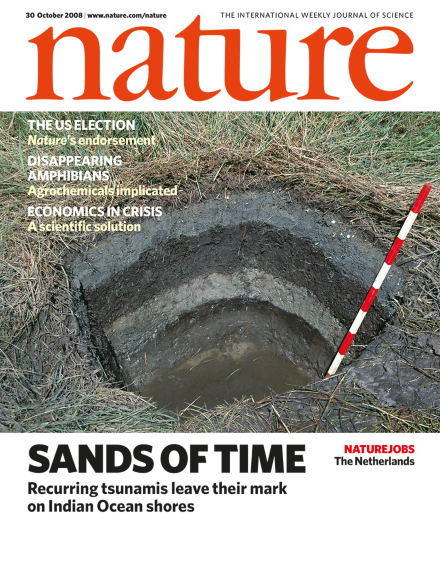 หนึ่งในผลการศึกษาที่ได้รับการยอมรับและอ้างอิงสูง (อ้างอิงโดย 169 เพเพอร์: ข้อมูล ณ วันที่ 23 ธันวาคม 2557) คือ รายงานการค้นพบสึนามิโบราณ ในประเทศไทยซึ่งแสดงหลักฐานทางธรณีวิทยา (ชั้นทราย) ที่ยืนยันว่าในอดีตเคยเกิดเหตุการณ์สึนามิมาแล้วในพื้นที่นี้มาแล้วอย่างน้อย 3 ครั้ง ครั้งล่าสุดก่อนเหตุการณ์สึนามิปี 2547 คือเมื่อประมาณ 600 ปีที่ผ่านมา
ผลการศึกษาครั้งนี้มีความสำคัญอย่างมาก เนื่องจากในการที่เราจะบรรเทาความเสียหายและความเสี่ยงจากเหตุการณ์สึนามิในภูมิภาคนี้ในอนาคต เราจำเป็นต้องทราบประวัติการเกิดแผ่นดินไหวขนาดใหญ่และสึนามิตามแนวร่องลึกซุนดา
แต่เนื่องจากข้อมูลแผ่นดินไหวในพื้นที่นี้ (ทั้งที่เป็นการบันทึกโดยเครื่องมือและการบันทึกทางประวัติศาตร์) มีจำกัดและมีข้อมูลย้อนไปไม่เกิน 400 ปี ทำให้ข้อมูลที่มีอยู่ไม่สมบูรณ์ ไม่สามารถประเมินภัยจากแผ่นดินไหวขนาดใหญ่และสึนามิ (ซึ่งจำเป็นต้องใช้ข้อมูลที่ยาวนานกว่านี้) ได้ ทำให้ทีมวิจัยต้องทำการศึกษา หาหลักฐานทางธรณีวิทยา เพื่อมายืนยันการเกิดเหตุการณ์เหล่านี้ในอดีต รวมทั้งอายุและความรุนแรงของเหตุการณ์เหล่านี้ด้วย
ในเวลาต่อมา ทีมวิจัยในหลายประเทศรอบมหาสมุทรอินเดียได้รายงานการค้นพบสึนามิโบราณ และอายุของสึนามิโบราณเหล่านี้ตลอดช่วง 6 ปีที่ผ่านมา ซึ่งข้อมูลต่างๆเหล่านี้มีประโยชน์ในการประเมินความเสี่ยงการเกิดแผ่นดินไหวและสึนามิในภูมิภาคนี้ในอนาคตต่อไป ในปัจจุบันทีมวิจัยจากภาควิชาธรณีวิทยา ยังคงทำวิจัยเกี่ยวกับสึนามิอย่างต่อเนื่อง เพื่อให้ทราบอายุและความรุนแรงของเหตุการณ์สึนามิในอดีตที่มีผลกระทบต่อประเทศไทย
คนในพื้นที่ต้องเตรียมพร้อม
ทั้งนี้ข้อมูลยืนยันทางวิทยาศาสตร์ที่กล่าวมานั้น ถึงจะมีความสำคัญ แต่สิ่งที่สำคัญยิ่งกว่า คือการเตรียมความพร้อมของคนในพื้นที่ต่อเหตุการณ์พิบัติภัยสึนามิ เมื่อเราย้อนกลับมาดูความเปลี่ยนแปลงที่เกิดขึ้นในพื้นที่ประสบภัยในประเทศไทยหลังเหตุการณ์สึนามิ เราจะพบว่า ปัจจุบันเรามีศูนย์เตือนภัยสึนามิ มีระบบการเตือนภัย มีการติดตั้งหอสัญญาณเตือนภัย ป้ายเตือนภัย อาคารหลบภัย และการซ้อมหนีภัยสึนามิ ซึ่งเหล่านี้ ล้วนมีความสำคัญอย่างยิ่ง ในการป้องกันและบรรเทาความสูญเสียทั้งต่อชีวิตและทรัพย์สินจากเหตุการณ์สึนามิที่อาจเกิดขึ้นในอนาคต
ข้อมูลแนะนำ
- การ์ตูนวิทยาศาสตร์ “แจ๋วแหว๋ว กับเดอะแก๊งค์” ฉบับธรณีวิทยา
- Soft Quake: งานเขียนด้านธรณีวิทยา ที่แอบนินทา “แผ่นดินไหว” แบบเบาๆ
- เอกสารประกอบการบรรยายเกี่ยวกับการศึกษาสึนามิ
Boxing Day Tsunami 10 years later
26 December 2014 marks the 10 year anniversary of the catastrophic earthquake and tsunami. It is said to be the most devastating natural disaster in recorded history with more than 230,000 casualties in 14 countries, causing tremendous damages to infrastructure and properties and economic loss. The tsunami affected 6 provinces along the Andaman coast of Thailand with more than 5,000 people reported dead. The tsunami was unexpected in Thailand and other countries in the region. At the time, there was no tsunami warning center in Thailand or neighboring countries. There was no way of communicating the warning message of the impeding tsunami to the people on the affected coasts.
Epicenter of the earthquake was offshore of Banda Aceh, Sumatra, Indonesia, on the Sunda Trench which is a zone where the Indian Plate subducted beneath the Eurasian Plate. Magnitude of the earthquake is Mw 9.1-9.3 (it took scientists almost 2 years in revising the magnitude of this earthquake) which is considered 3rd largest earthquake. The results of study in the following months revealed that the rupture started from the epicenter and propagate northward to north of Andaman-Nicobar islands, a total of 1,300 km in length with rupture duration of almost 10 mins.
Earthquake and tsunami of 26 December 2004 is not only unexpected for the general public it is also unexpected in the scientific community, especially those who study subduction zone earthquake and tsunami, in terms of size and the location of the rupture area. This earthquake caused changes in some theories and scientific beliefs regarding the subduction zone earthquake, such as that the subduction zone capable of producing giant earthquake and resultant tsunami need not to be restricted to those with young plate age and a fast subducting rate. Moreover, there has been vast knowledge and scientific findings following this devastating earthquake and tsunami.
In Thailand alone there are also numerous research findings and publications (in various areas of study) following this earthquake and tsunami, both by foreign research teams and Thai teams. The Department of Geology, Faculty of Science, Chulalongkorn University was involved with post-tsunami surveying and assessing the physical impact of the tsunami along the Andaman coast of Thailand. The research team led by Prof. Montri Choowong studied tsunami sediments and published many papers in international peer-reviewed journals. Many of these publications have been cited frequently by tsunami researchers over the past 8 years.
One of the study’s result which is widely accepted and highly cited by other researchers (cited 169 times: data at 23 Dec 2014) is a report of paleotsunami deposits in Thailand published in Nature. The paper detailed evidence of past recurring tsunamis (at least 3 events before 2004) in this region in the form of sand sheets. The youngest of the paleotsunami is about 600 years old. This finding is very important because in order to mitigate future losses and reduce risk from future tsunami in this region we need to know the history of past giant and great earthquakes and tsunamis along the Sunda Trench. Because available data in terms of instrumentally recorded and historical accounts in this area only stretch back about 400 years which is far from complete to allow assessing the risk from giant and great earthquakes and tsunamis which need a longer record. The research team had to search for geological evidence (in the form of sand sheets) to confirm the recurring nature of the tsunami, including their ages and sizes, in this region. In the following years many research teams in countries around the Indian Ocean reported similar finding of paleotsunamis and their ages. This information is very important in assessing risk from future earthquakes and tsunamis of the region. The research team from Department of Geology continues studying tsunami deposits to reveal ages and sizes of past tsunamis affected Thailand.
All scientific knowledge and findings mentioned above is important, but more importantly is the level of preparedness of the people in the tsunami risk area. The important improvement in Thailand after the tsunami is that now we have tsunami warning center and a warning system in place. In the tsunami risk area we have sirens and tsunami signage installed, tsunami shelters were built and we have evacuation drills. All of these are part of the tsunami warning system which is of the utmost importance in preventing and reducing future loss of lives and properties from future tsunamis.